Geolocate

Mutha topographic map

Click on the map to display elevation.

About this map

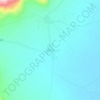
Name: Mutha topographic map, elevation, terrain.

Location: Mutha, Kitui South, Kitui County, Kenya (-1.82812 38.40792 -1.78812 38.44792)

Average elevation: 636 m

Minimum elevation: 587 m

Maximum elevation: 981 m

Other topographic maps

Click on a map to view its topography, its elevation and its terrain.

Mutomo

Kenya > Kitui County > Kitui South

Average elevation: 904 m

Gear up for your next adventure:

🔭Outdoor Binoculars - Lightweight binoculars for birdwatching and hiking
🔨Vehicle Emergency Tool - Safety tool for remote road trips to trailheads
💡Portable Camping Lamp - Rechargeable lamp for campsite lighting
🪑Ultralight Camping Stool - Compact seating for rest stops during long hikes
🧭GPS Handheld Device - Reliable GPS navigation for outdoor adventures

As an Amazon Associate, this site earns from qualifying purchases at no extra cost to you.