
River Bennet topographic map
Interactive map
Click on the map to display elevation.
About this map
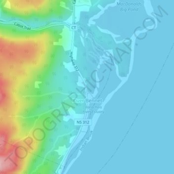
Name: River Bennet topographic map, elevation, terrain.
Average elevation: 33 m
Minimum elevation: -2 m
Maximum elevation: 181 m
Municipality of Victoria County trails, hiking, mountain biking, running and outdoor activities
Other topographic maps
Click on a map to view its topography, its elevation and its terrain.
Boularderie
Canada > Nova Scotia > Municipality of Victoria County > Ross Ferry
Average elevation: 50 m
Roundhill Lakes
Canada > Nova Scotia > Municipality of Victoria County > Cape Breton Highlands National Park
Average elevation: 427 m
Upper Kempt Head
Canada > Nova Scotia > Municipality of Victoria County > Kempt Head
Average elevation: 20 m
The Lookoff
Canada > Nova Scotia > Municipality of Victoria County > Forks Baddeck
Average elevation: 301 m