
Make a donation
Gear up for your next adventure:
As an Amazon Associate, this site earns from qualifying purchases at no extra cost to you.
Duisburg topographic map
Click on the map to display elevation.
Make a donation
Gear up for your next adventure:
As an Amazon Associate, this site earns from qualifying purchases at no extra cost to you.
Duisburg
Duisburg ligt op een hoogte van 60-102 meter, op het Plateau van Duisburg, tussen het dal van de Voer en de IJse.
Make a donation
Gear up for your next adventure:
As an Amazon Associate, this site earns from qualifying purchases at no extra cost to you.
About this map
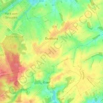
Name: Duisburg topographic map, elevation, terrain.
Location: Duisburg, Tervuren, Leuven, Vlaams-Brabant, Vlaanderen, België (50.79678 4.52111 50.82516 4.58657)
Average elevation: 85 m
Minimum elevation: 51 m
Maximum elevation: 119 m
Make a donation
Gear up for your next adventure:
As an Amazon Associate, this site earns from qualifying purchases at no extra cost to you.
Other topographic maps
Click on a map to view its topography, its elevation and its terrain.