
Make a donation
Gear up for your next adventure:
As an Amazon Associate, this site earns from qualifying purchases at no extra cost to you.
Keizersbron topographic map
Click on the map to display elevation.
Make a donation
Gear up for your next adventure:
As an Amazon Associate, this site earns from qualifying purchases at no extra cost to you.
About this map
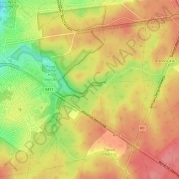
Name: Keizersbron topographic map, elevation, terrain.
Average elevation: 96 m
Minimum elevation: 46 m
Maximum elevation: 126 m
Make a donation
Gear up for your next adventure:
As an Amazon Associate, this site earns from qualifying purchases at no extra cost to you.
Other topographic maps
Click on a map to view its topography, its elevation and its terrain.
Vossem
België > Vlaams-Brabant > Leuven > Tervuren
Vossem ligt op het Brabants Plateau op een hoogte van 52-96 meter. De plaats ligt aan de Voer. Natuurgebieden in de directe omgeving zijn het Twaalf Apostelenbos en het Moorselbos.
Average elevation: 74 m
Duisburg
België > Vlaams-Brabant > Leuven > Tervuren
Duisburg ligt op een hoogte van 60-102 meter, op het Plateau van Duisburg, tussen het dal van de Voer en de IJse.
Average elevation: 85 m