Geolocate

Breukelen topographic map

Click on the map to display elevation.

About this map

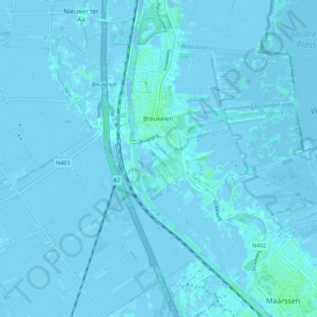
Name: Breukelen topographic map, elevation, terrain.

Location: Breukelen, Stichtse Vecht, Utrecht, Netherlands (52.13861 4.95156 52.19046 5.04642)

Average elevation: 0 m

Minimum elevation: -5 m

Maximum elevation: 5 m

Other topographic maps

Click on a map to view its topography, its elevation and its terrain.

Amersfoortse Berg

Netherlands > Utrecht > Amersfoort

Average elevation: 19 m

Cabauw

Netherlands > Utrecht

Average elevation: -1 m

Palestina

Netherlands > Utrecht > Amersfoort

Average elevation: 2 m

Breedeveen

Netherlands > Utrecht > Leersum

Average elevation: 15 m

Amerongse Berg

Netherlands > Utrecht > Amerongen

Average elevation: 34 m

Eembrugge

Netherlands > Utrecht > Baarn

Average elevation: 1 m

Graaf

Netherlands > Utrecht > Lopik

Average elevation: 0 m

Gear up for your next adventure:

🪑Insulated Seat Pad - Protect your seat from cold rocks and wet logs
🛌Down Sleeping Bag - Superior warmth-to-weight ratio for cold nights
🦯Trekking Poles - Reduced impact on joints for steep topographic climbs
🧴Sunscreen SPF - Broad-spectrum sunscreen for outdoor activities
🧦Outdoor Socks - Durable socks designed for hiking and outdoor sports

As an Amazon Associate, this site earns from qualifying purchases at no extra cost to you.