Geolocate

Tubigon topographic map

Click on the map to display elevation.

About this map

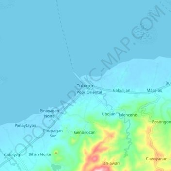
Name: Tubigon topographic map, elevation, terrain.

Location: Tubigon, Bohol, Central Visayas, 6329, Philippines (9.91153 123.92189 9.99153 124.00189)

Average elevation: 32 m

Minimum elevation: -4 m

Maximum elevation: 344 m

Other topographic maps

Click on a map to view its topography, its elevation and its terrain.

Boyo-an

Philippines > Bohol > Candijay

Average elevation: 43 m

Bingag

Philippines > Bohol > Dauis

Average elevation: 19 m

Panglao

Philippines > Bohol > Panglao

Average elevation: 4 m

Gear up for your next adventure:

🥾Trekking Boots - Durable boots for long-distance trekking
🍽️Titanium Camping Spork - Ultralight and indestructible eating utensil
🥾Trekking Poles - Adjustable trekking poles to reduce knee stress and improve stability
🥾Mountain Trail Shoes - High-traction shoes for mountain trails
Lightweight Backpacking Tent - Compact tent for efficient hiking trips

As an Amazon Associate, this site earns from qualifying purchases at no extra cost to you.