
Budenheim topographic map
Interactive map
Click on the map to display elevation.
About this map
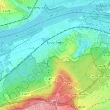
Name: Budenheim topographic map, elevation, terrain.
Average elevation: 113 m
Minimum elevation: 79 m
Maximum elevation: 197 m
Budenheim's greatest elevation is the Lenneberg at 176.8 m, which is in the Lennebergwald. At this spot stands the Lennebergturm (tower), dedicated in 1880 and belonging to the Wander- und Lennebergverein Rheingold Mainz e. V. (a hiking club).
Other topographic maps
Click on a map to view its topography, its elevation and its terrain.
Ingelheim am Rhein
Germany > Rhineland-Palatinate > Landkreis Mainz-Bingen
Ingelheim am Rhein, Landkreis Mainz-Bingen, Rhineland-Palatinate, Germany
Average elevation: 157 m
Oppenheim
Germany > Rhineland-Palatinate > Landkreis Mainz-Bingen
Oppenheim, Rhein-Selz, Landkreis Mainz-Bingen, Rhineland-Palatinate, 55276, Germany
Average elevation: 121 m
Nierstein
Germany > Rhineland-Palatinate > Landkreis Mainz-Bingen
Nierstein, Rhein-Selz, Landkreis Mainz-Bingen, Rhineland-Palatinate, 55283, Germany
Average elevation: 124 m