
Make a donation
Gear up for your next adventure:
As an Amazon Associate, this site earns from qualifying purchases at no extra cost to you.
Kicukiro District topographic map
Click on the map to display elevation.
Make a donation
Gear up for your next adventure:
As an Amazon Associate, this site earns from qualifying purchases at no extra cost to you.
About this map
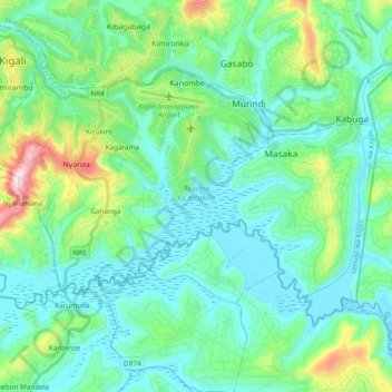
Name: Kicukiro District topographic map, elevation, terrain.
Location: Kicukiro District, Kigali City, Rwanda (-2.07982 30.04897 -1.95363 30.23934)
Average elevation: 1,428 m
Minimum elevation: 1,331 m
Maximum elevation: 1,809 m
Make a donation
Gear up for your next adventure:
As an Amazon Associate, this site earns from qualifying purchases at no extra cost to you.
Other topographic maps
Click on a map to view its topography, its elevation and its terrain.
Kigali
Rwanda > Kigali City > Nyarugenge District
Kigali is located in the centre of Rwanda, at 1°57′S 30°4′E. Like the rest of Rwanda it uses Central Africa Time, and is two hours ahead of Coordinated Universal Time (UTC+02:00) throughout the year. The city is coterminous with the province of Kigali, one of the five provinces of Rwanda introduced in…
Average elevation: 1,530 m
Make a donation
Gear up for your next adventure:
As an Amazon Associate, this site earns from qualifying purchases at no extra cost to you.