Geolocate

Olabe topographic map

Click on the map to display elevation.

About this map

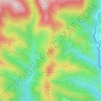
Name: Olabe topographic map, elevation, terrain.

Location: Olabe, Urraúl Alto, Prepirineo, Navarra, 31448, España (42.80232 -1.26182 42.80242 -1.26172)

Average elevation: 751 m

Minimum elevation: 604 m

Maximum elevation: 944 m

Other topographic maps

Click on a map to view its topography, its elevation and its terrain.

Urraúl Alto

España > Navarra > Prepirineo > Urraúl Alto

Average elevation: 773 m

Ongotz

España > Navarra > Prepirineo > Urraúl Alto > Ongotz

Average elevation: 736 m

Gear up for your next adventure:

🚲MTB Frame Bag - Carry tools and maps directly on your bicycle frame
🥫Freeze-Dried Meals - Lightweight, high-calorie nutrition for multi-day treks
🧦Hiking Liner Socks - Thin base layer to prevent friction and blisters
🧦Outdoor Socks - Durable socks designed for hiking and outdoor sports
❄️Traction Ice Cleats - Slip-on spikes for icy trails and winter hiking

As an Amazon Associate, this site earns from qualifying purchases at no extra cost to you.