Geolocate

Kearsley topographic map

Click on the map to display elevation.

About this map
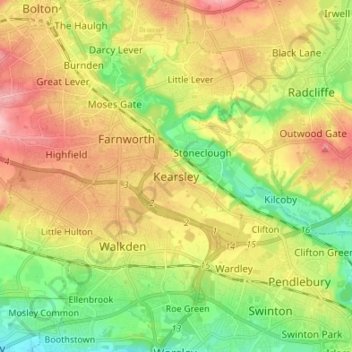
Name: Kearsley topographic map, elevation, terrain.

Location: Kearsley, Bolton, Greater Manchester, England, BL4 8NP, United Kingdom (53.50014 -2.41796 53.58014 -2.33796)

Average elevation: 83 m

Minimum elevation: 26 m

Maximum elevation: 149 m

Other topographic maps

Click on a map to view its topography, its elevation and its terrain.

Westhoughton

United Kingdom > England > Bolton > Daisy Hill

Average elevation: 97 m

Westhoughton

United Kingdom > England > Bolton > Daisy Hill

Average elevation: 97 m

Gear up for your next adventure:

🥾Trekking Poles - Adjustable trekking poles to reduce knee stress and improve stability
🧰Survival Kit - Essential gear for emergencies in the wilderness
🥾Trail Hiking Boots - Supportive boots for rough trails
🔋Emergency Crank Radio - Weather alerts and power without needing batteries
🧴Insect Repellent - Protect yourself from bugs during outdoor adventures

As an Amazon Associate, this site earns from qualifying purchases at no extra cost to you.