Geolocate

Leda topographic map

Click on the map to display elevation.

About this map

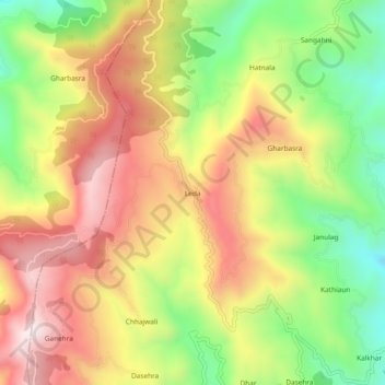
Name: Leda topographic map, elevation, terrain.

Location: Leda, Mandi, Himachal Pradesh, 175036, India (31.53475 76.80556 31.57475 76.84556)

Average elevation: 1,335 m

Minimum elevation: 1,020 m

Maximum elevation: 1,634 m

Other topographic maps

Click on a map to view its topography, its elevation and its terrain.

Beas River

India > Himachal Pradesh > Mandi > Pandoh

Average elevation: 962 m

Gear up for your next adventure:

🥘Camping Cookware Set - Compact nesting pots and pans for trail cooking
Tent Footprint - Protect tent floor and increase durability
🩹Moleskin Blister Pads - Direct protection for painful foot pressure points
Family Camping Tent - Spacious tent suitable for family camping trips
🧊Insulated Water Bottle - Keeps drinks cold in summer and prevents freezing in winter

As an Amazon Associate, this site earns from qualifying purchases at no extra cost to you.