Geolocate

St. Osyth topographic map

Click on the map to display elevation.

About this map

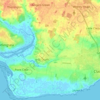
Name: St. Osyth topographic map, elevation, terrain.

Location: St. Osyth, St Osyth, Tendring, Essex, England, United Kingdom (51.76753 1.00966 51.84606 1.13191)

Average elevation: 12 m

Minimum elevation: -3 m

Maximum elevation: 31 m

Other topographic maps

Click on a map to view its topography, its elevation and its terrain.

Mill Dam Lake

United Kingdom > England > Essex > St Osyth

Average elevation: 9 m

Gear up for your next adventure:

💡LED Headlamp - Hands-free illumination for night hiking and camping
🔦LED Headtorch - Bright and durable light for night activities
🛌Insulated Sleeping Pad - Critical thermal barrier between you and the cold ground
🥫Freeze-Dried Meals - Lightweight, high-calorie nutrition for multi-day treks
🛶Waterproof Dry Bags - Keep electronics and clothes dry during river crossings

As an Amazon Associate, this site earns from qualifying purchases at no extra cost to you.