Geolocate

Castle Hedingham topographic map

Click on the map to display elevation.

About this map

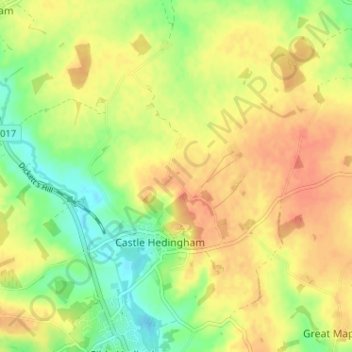
Name: Castle Hedingham topographic map, elevation, terrain.

Location: Castle Hedingham, Braintree, Essex, England, United Kingdom (51.97862 0.57390 52.01803 0.62823)

Average elevation: 68 m

Minimum elevation: 42 m

Maximum elevation: 89 m

Other topographic maps

Click on a map to view its topography, its elevation and its terrain.

Ashen

United Kingdom > England > Braintree > Ashen

Average elevation: 72 m

Doe's Corner

United Kingdom > England > Braintree > Doe's Corner

Average elevation: 24 m

Gear up for your next adventure:

🧴Insect Repellent - Protect yourself from bugs during outdoor adventures
💧Collapsible Water Bottle - Space-saving water bottle for outdoor activities
💡Portable Camping Lamp - Rechargeable lamp for campsite lighting
🧭GPS Outdoor Watch - Smart watch for navigation and fitness tracking in nature
🥾Durable Hiking Shoes - Long-lasting shoes for frequent hiking

As an Amazon Associate, this site earns from qualifying purchases at no extra cost to you.