Geolocate

Feering topographic map

Click on the map to display elevation.

About this map

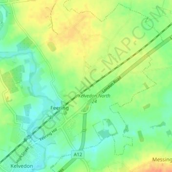
Name: Feering topographic map, elevation, terrain.

Location: Feering, Braintree, Essex, England, United Kingdom (51.83452 0.69033 51.87167 0.75290)

Average elevation: 37 m

Minimum elevation: 21 m

Maximum elevation: 59 m

Other topographic maps

Click on a map to view its topography, its elevation and its terrain.

Ashen

United Kingdom > England > Braintree > Ashen

Average elevation: 72 m

Doe's Corner

United Kingdom > England > Braintree > Doe's Corner

Average elevation: 24 m

Gear up for your next adventure:

🦯Trekking Poles - Reduced impact on joints for steep topographic climbs
🧴First Aid Kit - Essential first aid supplies for outdoor emergencies
🔦LED Headlamp - Hands-free lighting for early morning starts or late finishes
💡Portable Camping Lamp - Rechargeable lamp for campsite lighting
🚲Heavy Duty Bike Lock - Secure your bike at the trailhead or during stops

As an Amazon Associate, this site earns from qualifying purchases at no extra cost to you.