Geolocate

Canon topographic map

Click on the map to display elevation.

About this map

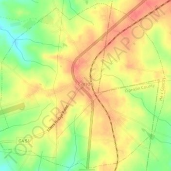
Name: Canon topographic map, elevation, terrain.

Location: Canon, Franklin County, Georgia, United States (34.33171 -83.12902 34.36007 -83.09327)

Average elevation: 268 m

Minimum elevation: 234 m

Maximum elevation: 290 m

Other topographic maps

Click on a map to view its topography, its elevation and its terrain.

Lavonia

United States > Georgia > Franklin County > Lavonia > Lavonia

Average elevation: 247 m

Sandy Cross

United States > Georgia > Franklin County

Average elevation: 235 m

Gear up for your next adventure:

🥽Outdoor Goggles - Protective eyewear for outdoor activities
🧣Evaporative Cooling Towel - Beat the heat during intense summer climbs
🧦Crew Hiking Socks - Comfortable socks for long-distance hikes
🚑Survival Whistle - Signal for help across long distances in mountains
🥾Waterproof Hiking Shoes - Durable shoes for wet and rugged trails

As an Amazon Associate, this site earns from qualifying purchases at no extra cost to you.