Geolocate

Sandy Cross topographic map

Click on the map to display elevation.

About this map

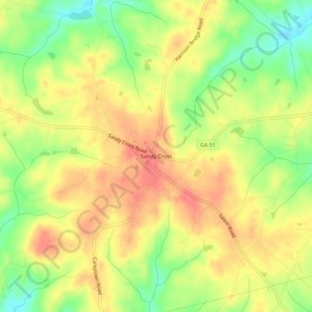
Name: Sandy Cross topographic map, elevation, terrain.

Location: Sandy Cross, Franklin County, Georgia, United States (34.26733 -83.24599 34.30733 -83.20599)

Average elevation: 235 m

Minimum elevation: 197 m

Maximum elevation: 263 m

Other topographic maps

Click on a map to view its topography, its elevation and its terrain.

Canon

United States > Georgia > Franklin County

Average elevation: 268 m

Gumlog

United States > Georgia > Franklin County

Average elevation: 230 m

Gear up for your next adventure:

🧢Hiking Hat - Sun-protective and breathable hats for long treks
Camping Groundsheet - Protect your tent from moisture and dirt
💧Filtered Water Bottle - Safe drinking water on the go
🔋Solar Power Bank - Keep your GPS and devices charged during long outdoor trips
🥤Collapsible Travel Cup - Saves space and weight in your mess kit

As an Amazon Associate, this site earns from qualifying purchases at no extra cost to you.