
翔安区 topographic map
Interactive map
Click on the map to display elevation.
About this map
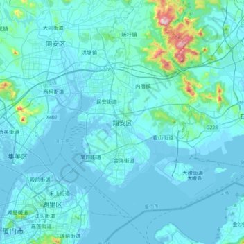
Name: 翔安区 topographic map, elevation, terrain.
Location: 翔安区, 厦门市, 福建省, 361102, 中国 (24.46198 118.08320 24.78198 118.40320)
Average elevation: 36 m
Minimum elevation: -4 m
Maximum elevation: 549 m
Other topographic maps
Click on a map to view its topography, its elevation and its terrain.