
Yorba Linda topographic map
Interactive map
Click on the map to display elevation.
About this map
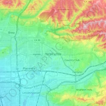
Name: Yorba Linda topographic map, elevation, terrain.
Location: Yorba Linda, Orange County, California, United States (33.86339 -117.84583 33.91844 -117.68345)
Average elevation: 175 m
Minimum elevation: 47 m
Maximum elevation: 505 m
Other topographic maps
Click on a map to view its topography, its elevation and its terrain.
Rancho Mission Viejo Ecological Reserve
United States > California > Orange County
Average elevation: 160 m
Huntington Harbor
United States > California > Orange County > Huntington Beach > Huntington Harbor
Average elevation: 4 m
Huntington Beach
United States > California > Orange County > Huntington Beach
Average elevation: 16 m
San Joaquin Hills
United States > California > Orange County > Newport Beach > San Joaquin Hills
Average elevation: 153 m