Geolocate

Orange topographic map

Click on the map to display elevation.

About this map

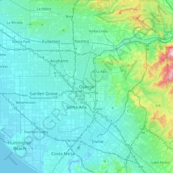
Name: Orange topographic map, elevation, terrain.

Location: Orange, Orange County, California, 92866, United States (33.62726 -118.01031 33.94726 -117.69031)

Average elevation: 117 m

Minimum elevation: -3 m

Maximum elevation: 897 m

Gear up for your next adventure:

🥘Camping Cookware Set - Compact nesting pots and pans for trail cooking
💡Portable Camping Lamp - Rechargeable lamp for campsite lighting
Camping Coffee Maker - Brew fresh coffee anywhere on the topographic map
💧Hydration Pack - Hands-free hydration system for long hikes
🧭Orienteering Kit - Tools for map reading and navigation in the wild

As an Amazon Associate, this site earns from qualifying purchases at no extra cost to you.