
Make a donation
Gear up for your next adventure:
As an Amazon Associate, this site earns from qualifying purchases at no extra cost to you.
Lac Vert topographic map
Click on the map to display elevation.
Make a donation
Gear up for your next adventure:
As an Amazon Associate, this site earns from qualifying purchases at no extra cost to you.
About this map
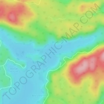
Name: Lac Vert topographic map, elevation, terrain.
Average elevation: 216 m
Minimum elevation: 156 m
Maximum elevation: 320 m
Make a donation
Gear up for your next adventure:
As an Amazon Associate, this site earns from qualifying purchases at no extra cost to you.
Other topographic maps
Click on a map to view its topography, its elevation and its terrain.
Lac à la Truite
Canada > Québec > Les Collines-de-l'Outaouais > Val-des-Monts
Average elevation: 325 m
Lac du Bois Franc
Canada > Québec > Les Collines-de-l'Outaouais > Val-des-Monts
Average elevation: 229 m
Saint-Pierre de Wakefield
Canada > Québec > Les Collines-de-l'Outaouais > Val-des-Monts
Average elevation: 224 m
Make a donation
Gear up for your next adventure:
As an Amazon Associate, this site earns from qualifying purchases at no extra cost to you.