
Toa Baja topographic map
Click on the map to display elevation.
Toa Baja
The elevations range from 200 to 490 feet (60 to 150 meters) above sea level, with most of its highest parts located in the south. The rest of the area is mostly plain. The northern part of Toa Baja is characterized for its mangroves and marshes, while the southern part is classified as typical karst area.
About this map
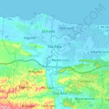
Name: Toa Baja topographic map, elevation, terrain.
Location: Toa Baja, Puerto Rico, United States (18.38927 -66.26437 18.47603 -66.13365)
Average elevation: 32 m
Minimum elevation: -3 m
Maximum elevation: 204 m
Other topographic maps
Click on a map to view its topography, its elevation and its terrain.