
High Wycombe topographic map
Click on the map to display elevation.
About this map
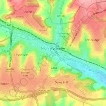
Name: High Wycombe topographic map, elevation, terrain.
Location: High Wycombe, Buckinghamshire, England, United Kingdom (51.61000 -0.79988 51.64953 -0.72864)
Average elevation: 125 m
Minimum elevation: 57 m
Maximum elevation: 191 m
Other topographic maps
Click on a map to view its topography, its elevation and its terrain.
Hotley Bottom
United Kingdom > England > Buckinghamshire > Great Missenden > Prestwood
Average elevation: 182 m
Wapsey's Wood Landfill Site
United Kingdom > England > Buckinghamshire > Beaconsfield > Jordans
Average elevation: 93 m
Doddershall Wood
United Kingdom > England > Buckinghamshire > Grendon Underwood
Average elevation: 77 m