
Make a donation
Gear up for your next adventure:
As an Amazon Associate, this site earns from qualifying purchases at no extra cost to you.
Orange County topographic map
Click on the map to display elevation.
Make a donation
Gear up for your next adventure:
As an Amazon Associate, this site earns from qualifying purchases at no extra cost to you.
About this map
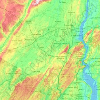
Name: Orange County topographic map, elevation, terrain.
Location: Orange County, New York, United States (41.14303 -74.76202 41.63004 -73.94761)
Average elevation: 194 m
Minimum elevation: -3 m
Maximum elevation: 695 m
Make a donation
Gear up for your next adventure:
As an Amazon Associate, this site earns from qualifying purchases at no extra cost to you.
Other topographic maps
Click on a map to view its topography, its elevation and its terrain.
Roundtop Mountain
United States > New York > Ulster County > Town of Woodstock
Average elevation: 505 m
Make a donation
Gear up for your next adventure:
As an Amazon Associate, this site earns from qualifying purchases at no extra cost to you.
Center Island
United States > New York > Albany County > Town of Colonie > Village of Green Island
Average elevation: 24 m
Make a donation
Gear up for your next adventure:
As an Amazon Associate, this site earns from qualifying purchases at no extra cost to you.
Make a donation
Gear up for your next adventure:
As an Amazon Associate, this site earns from qualifying purchases at no extra cost to you.
Stanley Manor
United States > New York > Onondaga County > Fairmount > Town of Camillus
Average elevation: 189 m
Niagara Escarpment
United States > New York > Niagara County > City of Lockport
Average elevation: 165 m
Make a donation
Gear up for your next adventure:
As an Amazon Associate, this site earns from qualifying purchases at no extra cost to you.
Salisbury Meadow
United States > New York > Rockland County > Town of Stony Point
Average elevation: 97 m
Make a donation
Gear up for your next adventure:
As an Amazon Associate, this site earns from qualifying purchases at no extra cost to you.
Make a donation
Gear up for your next adventure:
As an Amazon Associate, this site earns from qualifying purchases at no extra cost to you.
Black Rock Mountain
United States > New York > Orange County > Town of Tuxedo
Average elevation: 330 m
Heath Ridge
United States > New York > Westchester County > Village of Scarsdale
Average elevation: 66 m
Make a donation
Gear up for your next adventure:
As an Amazon Associate, this site earns from qualifying purchases at no extra cost to you.
Make a donation
Gear up for your next adventure:
As an Amazon Associate, this site earns from qualifying purchases at no extra cost to you.
Wilmot Woods
United States > New York > Westchester County > City of New Rochelle
Average elevation: 70 m
Make a donation
Gear up for your next adventure:
As an Amazon Associate, this site earns from qualifying purchases at no extra cost to you.
Forest Knolls
United States > New York > Westchester County > City of New Rochelle
Average elevation: 34 m
Black Creek Village
United States > New York > Niagara County > City of Niagara Falls
Average elevation: 176 m
Canoe Place
United States > New York > Suffolk County > Hampton Bays > Town of Southampton
Average elevation: 10 m
Make a donation
Gear up for your next adventure:
As an Amazon Associate, this site earns from qualifying purchases at no extra cost to you.
Make a donation
Gear up for your next adventure:
As an Amazon Associate, this site earns from qualifying purchases at no extra cost to you.
Carpenter Hill
United States > New York > Hamilton County > Town of Lake Pleasant
Average elevation: 554 m
Oscawana Corners
United States > New York > Putnam County > Town of Putnam Valley
Average elevation: 158 m
Make a donation
Gear up for your next adventure:
As an Amazon Associate, this site earns from qualifying purchases at no extra cost to you.
Sister Island
United States > New York > Saint Lawrence County > Town of Hammond
Average elevation: 113 m
Height of Land Mountain
United States > New York > Warren County > Town of Johnsburg
Average elevation: 759 m
Cross River
United States > New York > Westchester County > Town of Lewisboro
Average elevation: 155 m
Make a donation
Gear up for your next adventure:
As an Amazon Associate, this site earns from qualifying purchases at no extra cost to you.
Make a donation
Gear up for your next adventure:
As an Amazon Associate, this site earns from qualifying purchases at no extra cost to you.
Mount Pisgah
United States > New York > Essex County > Village of Saranac Lake
Average elevation: 502 m
Make a donation
Gear up for your next adventure:
As an Amazon Associate, this site earns from qualifying purchases at no extra cost to you.
Make a donation
Gear up for your next adventure:
As an Amazon Associate, this site earns from qualifying purchases at no extra cost to you.
Make a donation
Gear up for your next adventure:
As an Amazon Associate, this site earns from qualifying purchases at no extra cost to you.
Albany
United States > New York > Albany
The highest natural point in Albany is a USGS benchmark near the Loudonville Reservoir off Birch Hill Road, at 378 feet (115 m) above sea level. The lowest point is sea level at the Hudson River (the average water elevation is 2 feet (0.61 m)), which is still technically an estuary at Albany and is affected by…
Average elevation: 114 m
Make a donation
Gear up for your next adventure:
As an Amazon Associate, this site earns from qualifying purchases at no extra cost to you.
North Fair Haven
United States > New York > Cayuga County > Fair Haven > North Fair Haven
Average elevation: 82 m
Make a donation
Gear up for your next adventure:
As an Amazon Associate, this site earns from qualifying purchases at no extra cost to you.
Colonial Acres
United States > New York > Westchester County > Scarsdale > Colonial Acres
Average elevation: 55 m
Make a donation
Gear up for your next adventure:
As an Amazon Associate, this site earns from qualifying purchases at no extra cost to you.
Make a donation
Gear up for your next adventure:
As an Amazon Associate, this site earns from qualifying purchases at no extra cost to you.
Pine Grove
United States > New York > Onondaga County > Town of Spafford > Pine Grove
Average elevation: 327 m
Elka Park
United States > New York > Greene County > Town of Hunter > Elka Park
Average elevation: 729 m
Make a donation
Gear up for your next adventure:
As an Amazon Associate, this site earns from qualifying purchases at no extra cost to you.
Beechmont
United States > New York > Westchester County > City of New Rochelle > Beechmont
Average elevation: 31 m
Parkside
United States > New York > Westchester County > City of Mount Vernon > Parkside
Average elevation: 27 m
Make a donation
Gear up for your next adventure:
As an Amazon Associate, this site earns from qualifying purchases at no extra cost to you.
Waterport
United States > New York > Orleans County > Town of Carlton > Waterport
Average elevation: 107 m
Lewiston Heights
United States > New York > Niagara County > Town of Lewiston > Village of Lewiston
Average elevation: 144 m
Make a donation
Gear up for your next adventure:
As an Amazon Associate, this site earns from qualifying purchases at no extra cost to you.
Diamond Point (hamlet)
United States > New York > Warren County > Town of Lake George
Average elevation: 191 m
Make a donation
Gear up for your next adventure:
As an Amazon Associate, this site earns from qualifying purchases at no extra cost to you.