
Make a donation
Gear up for your next adventure:
As an Amazon Associate, this site earns from qualifying purchases at no extra cost to you.
Landrum Watershed topographic map
Click on the map to display elevation.
Make a donation
Gear up for your next adventure:
As an Amazon Associate, this site earns from qualifying purchases at no extra cost to you.
About this map
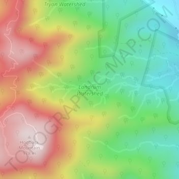
Name: Landrum Watershed topographic map, elevation, terrain.
Average elevation: 642 m
Minimum elevation: 363 m
Maximum elevation: 981 m
Make a donation
Gear up for your next adventure:
As an Amazon Associate, this site earns from qualifying purchases at no extra cost to you.
Other topographic maps
Click on a map to view its topography, its elevation and its terrain.
Orchard Acres
United States > South Carolina > Greenville County > Wade Hampton
Average elevation: 292 m
Crescentwood Village
United States > South Carolina > Greenville County > Mauldin
Average elevation: 276 m
Make a donation
Gear up for your next adventure:
As an Amazon Associate, this site earns from qualifying purchases at no extra cost to you.