
Make a donation
Gear up for your next adventure:
As an Amazon Associate, this site earns from qualifying purchases at no extra cost to you.
Kern County topographic map
Click on the map to display elevation.
Make a donation
Gear up for your next adventure:
As an Amazon Associate, this site earns from qualifying purchases at no extra cost to you.
Kern County
Kern County suffers from severe air pollution. Particulates cause poor visibility, especially in the winter. Western Kern County lies in the San Joaquin Valley and the topography traps pollutants. Although the topography is not as unfavorable in eastern Kern County, eastern Kern County is a non-attainment area for particulates. Air pollution caused by particulates is "in the unhealthy range an average of 40 days a year, according to the American Lung Association's (ALA) 2018 State of the Air Report.
Make a donation
Gear up for your next adventure:
As an Amazon Associate, this site earns from qualifying purchases at no extra cost to you.
About this map
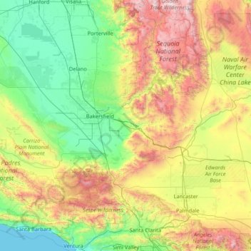
Name: Kern County topographic map, elevation, terrain.
Location: Kern County, California, United States (34.78973 -120.19415 35.79831 -117.61640)
Average elevation: 841 m
Minimum elevation: 0 m
Maximum elevation: 3,589 m
Make a donation
Gear up for your next adventure:
As an Amazon Associate, this site earns from qualifying purchases at no extra cost to you.
Other topographic maps
Click on a map to view its topography, its elevation and its terrain.