
Make a donation
Gear up for your next adventure:
As an Amazon Associate, this site earns from qualifying purchases at no extra cost to you.
Baker topographic map
Click on the map to display elevation.
Make a donation
Gear up for your next adventure:
As an Amazon Associate, this site earns from qualifying purchases at no extra cost to you.
About this map
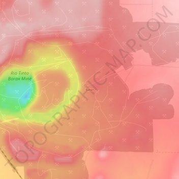
Name: Baker topographic map, elevation, terrain.
Location: Baker, Boron, Kern County, California, United States (35.02220 -117.68756 35.06220 -117.64756)
Average elevation: 765 m
Minimum elevation: 583 m
Maximum elevation: 815 m
Make a donation
Gear up for your next adventure:
As an Amazon Associate, this site earns from qualifying purchases at no extra cost to you.
Other topographic maps
Click on a map to view its topography, its elevation and its terrain.
Boron
United States > California > Kern County > Boron
Boron (formerly Amargo, Baker, Borate, and Kern)[4] is a census-designated place (CDP) in Kern County, California, United States. Boron is 15 miles (24 km) southwest of Red Rock Mountain at an elevation of 2,467 feet (752 m).[4] The population was 2,086 at the 2020 census, up from 2,025 at the 2000 census.…
Average elevation: 753 m