Geolocate

Bordalba topographic map

Click on the map to display elevation.

About this map

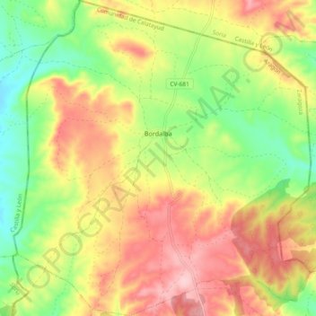
Name: Bordalba topographic map, elevation, terrain.

Location: Bordalba, Comunidad de Calatayud, Zaragoza, Aragon, Spain (41.37688 -2.12053 41.44579 -2.03398)

Average elevation: 947 m

Minimum elevation: 850 m

Maximum elevation: 1,046 m

Other topographic maps

Click on a map to view its topography, its elevation and its terrain.

Solana

Spain > Aragon > Comunidad de Calatayud > Calatayud

Average elevation: 874 m

Pico Agudo

Spain > Aragon > Comunidad de Calatayud > Codos

Average elevation: 963 m

Valderoy

Spain > Aragon > Comunidad de Calatayud > Ateca

Average elevation: 659 m

Gear up for your next adventure:

🧴Outdoor Sunscreen - High SPF protection for high-altitude UV exposure
🧴Insect Repellent - Protect yourself from bugs during outdoor adventures
🩹Compact First Aid Kit - Pre-packed essentials for common trail injuries
🛏️Sleeping Bag - Warm and compact sleeping bags for outdoor camping
🚲Heavy Duty Bike Lock - Secure your bike at the trailhead or during stops

As an Amazon Associate, this site earns from qualifying purchases at no extra cost to you.