Geolocate

Valbona topographic map

Click on the map to display elevation.

About this map

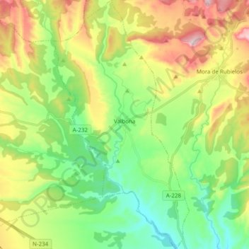
Name: Valbona topographic map, elevation, terrain.

Location: Valbona, Gúdar-Javalambre, Teruel, Aragon, 44430, Spain (40.16882 -0.85584 40.28464 -0.77181)

Average elevation: 1,007 m

Minimum elevation: 858 m

Maximum elevation: 1,261 m

Other topographic maps

Click on a map to view its topography, its elevation and its terrain.

Peñarroya

Spain > Aragon > Gúdar-Javalambre > Alcalá de la Selva

Average elevation: 1,834 m

Maya

Spain > Aragon > Gúdar-Javalambre > Mora de Rubielos

Average elevation: 1,120 m

Gear up for your next adventure:

🩹Compact First Aid Kit - Pre-packed essentials for common trail injuries
🏕️Camping Hammock - Integrated protection for sleeping between trees
🌬️Windproof Camp Stove - Efficient cooking even on exposed mountain peaks
🥾Trail Hiking Boots - Supportive boots for rough trails
🔨Vehicle Emergency Tool - Safety tool for remote road trips to trailheads

As an Amazon Associate, this site earns from qualifying purchases at no extra cost to you.