
Make a donation
Gear up for your next adventure:
As an Amazon Associate, this site earns from qualifying purchases at no extra cost to you.
Umboi Island topographic map
Click on the map to display elevation.
Make a donation
Gear up for your next adventure:
As an Amazon Associate, this site earns from qualifying purchases at no extra cost to you.
About this map
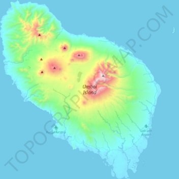
Name: Umboi Island topographic map, elevation, terrain.
Location: Umboi Island, Morobe, Momase Region, Papua New Guinea (-5.83131 147.74900 -5.45681 148.08810)
Average elevation: 177 m
Minimum elevation: 0 m
Maximum elevation: 1,602 m
Make a donation
Gear up for your next adventure:
As an Amazon Associate, this site earns from qualifying purchases at no extra cost to you.
Other topographic maps
Click on a map to view its topography, its elevation and its terrain.
Make a donation
Gear up for your next adventure:
As an Amazon Associate, this site earns from qualifying purchases at no extra cost to you.
Make a donation
Gear up for your next adventure:
As an Amazon Associate, this site earns from qualifying purchases at no extra cost to you.
Huon Gulf
Huon Gulf is a large gulf in eastern Papua New Guinea. It is bordered by Huon Peninsula in the north. Both are named after French explorer Jean-Michel Huon de Kermadec. Huon Gulf is a part of the Solomon Sea. Its northern boundary is marked by Cape Cretin, southern by Cape Longerue. The coast, which quickly…
Average elevation: 0 m
Make a donation
Gear up for your next adventure:
As an Amazon Associate, this site earns from qualifying purchases at no extra cost to you.
Make a donation
Gear up for your next adventure:
As an Amazon Associate, this site earns from qualifying purchases at no extra cost to you.
Make a donation
Gear up for your next adventure:
As an Amazon Associate, this site earns from qualifying purchases at no extra cost to you.
Make a donation
Gear up for your next adventure:
As an Amazon Associate, this site earns from qualifying purchases at no extra cost to you.