
Make a donation
Gear up for your next adventure:
As an Amazon Associate, this site earns from qualifying purchases at no extra cost to you.
Den Treek topographic map
Click on the map to display elevation.
Make a donation
Gear up for your next adventure:
As an Amazon Associate, this site earns from qualifying purchases at no extra cost to you.
About this map
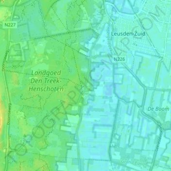
Name: Den Treek topographic map, elevation, terrain.
Location: Den Treek, Leusden, Utrecht, Nederland, 3832 RT, Nederland (52.08701 5.37176 52.12701 5.41176)
Average elevation: 7 m
Minimum elevation: 1 m
Maximum elevation: 20 m
Make a donation
Gear up for your next adventure:
As an Amazon Associate, this site earns from qualifying purchases at no extra cost to you.
Other topographic maps
Click on a map to view its topography, its elevation and its terrain.
Achterveld
De rooms-katholieke Sint Jozefkerk in Achterveld is van cultuurhistorische waarde. Het is een kruiskerk in neoromaanse stijl en heeft twee torens, een hoge vieringtoren en een lagere klokkentoren boven het ingangsportaal. Kenmerkend zijn de op wisselende hoogte aangebrachte tent- en zadeldaken. Het interieur…
Average elevation: 6 m
Leusden
In de zeventiende eeuw maakte de teelt van tabak een snelle groei door, dat in het gebied van de huidige gemeente rond 1700 haar hoogtepunt bereikte. Het gebied was hier goed geschikt voor, onder andere dankzij het gunstige klimaat, de gunstige bodem en goede verbindingen met belangrijke centra voor de handel…
Average elevation: 9 m
Make a donation
Gear up for your next adventure:
As an Amazon Associate, this site earns from qualifying purchases at no extra cost to you.