
Make a donation
Gear up for your next adventure:
As an Amazon Associate, this site earns from qualifying purchases at no extra cost to you.
Achterveld topographic map
Click on the map to display elevation.
Make a donation
Gear up for your next adventure:
As an Amazon Associate, this site earns from qualifying purchases at no extra cost to you.
Achterveld
De rooms-katholieke Sint Jozefkerk in Achterveld is van cultuurhistorische waarde. Het is een kruiskerk in neoromaanse stijl en heeft twee torens, een hoge vieringtoren en een lagere klokkentoren boven het ingangsportaal. Kenmerkend zijn de op wisselende hoogte aangebrachte tent- en zadeldaken. Het interieur van de kerk, inclusief de gewelven, is uitgevoerd in schoon metselwerk. Het gebouw is een rijksmonument.
Make a donation
Gear up for your next adventure:
As an Amazon Associate, this site earns from qualifying purchases at no extra cost to you.
About this map
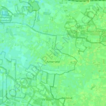
Name: Achterveld topographic map, elevation, terrain.
Location: Achterveld, Leusden, Utrecht, Nederland (52.12481 5.43815 52.15429 5.51408)
Average elevation: 6 m
Minimum elevation: 0 m
Maximum elevation: 10 m
Make a donation
Gear up for your next adventure:
As an Amazon Associate, this site earns from qualifying purchases at no extra cost to you.
Other topographic maps
Click on a map to view its topography, its elevation and its terrain.