Geolocate

St. Dennis topographic map

Click on the map to display elevation.

About this map

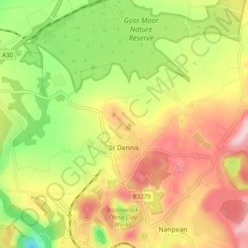
Name: St. Dennis topographic map, elevation, terrain.

Location: St. Dennis, St Dennis, Cornwall, England, United Kingdom (50.36613 -4.91797 50.40847 -4.84851)

Average elevation: 160 m

Minimum elevation: 29 m

Maximum elevation: 288 m

Gear up for your next adventure:

🥾Waterproof Trail Shoes - Shoes designed to handle wet terrain
🧴Waterproofing Spray - Restore the DWR coating on jackets and tents
🔋Solar Power Bank - Keep your GPS and devices charged during long outdoor trips
Backpacking Tent - Lightweight tent for long-distance hiking trips
🧰Survival Kit - Essential gear for emergencies in the wilderness

As an Amazon Associate, this site earns from qualifying purchases at no extra cost to you.