
Ben-Ahin topographic map
Interactive map
Click on the map to display elevation.
About this map
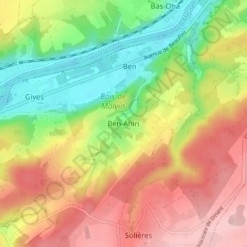
Name: Ben-Ahin topographic map, elevation, terrain.
Location: Ben-Ahin, Hoei, Luik, Wallonië, 5352, België (50.48332 5.15735 50.52332 5.19735)
Average elevation: 164 m
Minimum elevation: 64 m
Maximum elevation: 266 m
Other topographic maps
Click on a map to view its topography, its elevation and its terrain.
Vierset-Barse
Vierset-Barse, Modave, Hoei, Luik, Wallonië, 4577, België
Average elevation: 233 m
Villers-le-Bouillet
Villers-le-Bouillet, Hoei, Luik, Wallonië, 4530, België
Average elevation: 173 m
Arrête de Fairon
België > Luik > Hoei > Comblain-la-Tour
Arrête de Fairon, Comblain-la-Tour, Hamoir, Hoei, Luik, Wallonië, 4180, België
Average elevation: 182 m