Geolocate

Holt topographic map

Click on the map to display elevation.

About this map

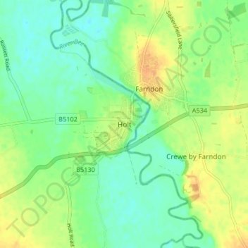
Name: Holt topographic map, elevation, terrain.

Location: Holt, Wrexham, Wales, LL13 9YN, United Kingdom (53.05849 -2.90241 53.09849 -2.86241)

Average elevation: 16 m

Minimum elevation: 4 m

Maximum elevation: 31 m

Other topographic maps

Click on a map to view its topography, its elevation and its terrain.

Gwersyllt

United Kingdom > Wales > Wrexham

Average elevation: 112 m

Penycae

United Kingdom > Wales > Wrexham

Average elevation: 350 m

Rhosddu

United Kingdom > Wales > Wrexham

Average elevation: 88 m

Bangor-on-Dee

United Kingdom > Wales > Wrexham

Average elevation: 30 m

Cefn

United Kingdom > Wales > Wrexham > Acrefair

Average elevation: 142 m

Gear up for your next adventure:

🧥Waterproof Pants - Keep dry during rainy hiking conditions
🧤Rechargeable Heated Gloves - Extreme warmth for Canadian winter expeditions
🧰Emergency Multi-Tool - Compact multi-tool for outdoor survival
🧣Evaporative Cooling Towel - Beat the heat during intense summer climbs
🧴Sunscreen SPF - Broad-spectrum sunscreen for outdoor activities

As an Amazon Associate, this site earns from qualifying purchases at no extra cost to you.