
Middlesex topographic map
Click on the map to display elevation.
About this map
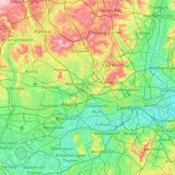
Name: Middlesex topographic map, elevation, terrain.
Average elevation: 46 m
Minimum elevation: -2 m
Maximum elevation: 161 m
Other topographic maps
Click on a map to view its topography, its elevation and its terrain.
Kitcher's Pond
United Kingdom > England > Hertfordshire > East Hertfordshire > Albury
Average elevation: 106 m
Tyttenhanger
United Kingdom > England > Hertfordshire > St Albans > Colney Heath
Average elevation: 83 m
Bushey Heath
United Kingdom > England > Hertfordshire > Hertsmere > Bushey Heath
Average elevation: 110 m
Stanstead Abbotts
United Kingdom > England > Hertfordshire > East Hertfordshire
Average elevation: 48 m