Geolocate

Nijverdal topographic map

Click on the map to display elevation.

About this map

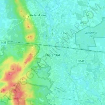
Name: Nijverdal topographic map, elevation, terrain.

Location: Nijverdal, Hellendoorn, Overijssel, Netherlands (52.32006 6.41584 52.40182 6.52079)

Average elevation: 18 m

Minimum elevation: 5 m

Maximum elevation: 70 m

Other topographic maps

Click on a map to view its topography, its elevation and its terrain.

Lemelerberg

Netherlands > Overijssel > Lemele

Average elevation: 19 m

Enschede

Netherlands > Overijssel > Enschede

Average elevation: 34 m

Zuurberg

Netherlands > Overijssel > Holten

Average elevation: 17 m

Frankhuis

Netherlands > Overijssel > Zwolle

Average elevation: 3 m

Witteberg

Netherlands > Overijssel

Average elevation: 57 m

Usselo

Netherlands > Overijssel > Enschede

Average elevation: 31 m

Tankenberg

Netherlands > Overijssel > de Lutte

Average elevation: 58 m

Helhuizen

Netherlands > Overijssel > Holten

Average elevation: 20 m

Gear up for your next adventure:

🧦Merino Wool Socks - Moisture-wicking comfort for long-distance hiking
🛏️Camping Sleeping Mat - Comfortable mats for sleeping outdoors
Backpacking Tent - Lightweight tent for long-distance hiking trips
🚑Survival Whistle - Signal for help across long distances in mountains
🧢Sun Protection Cap - Breathable cap to protect from sun exposure

As an Amazon Associate, this site earns from qualifying purchases at no extra cost to you.