Geolocate

Radcliff topographic map

Click on the map to display elevation.

About this map
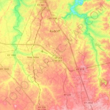
Name: Radcliff topographic map, elevation, terrain.

Location: Radcliff, Hardin County, Kentucky, 40160, United States (37.74857 -85.98154 37.87633 -85.88425)

Average elevation: 223 m

Minimum elevation: 145 m

Maximum elevation: 272 m

Other topographic maps

Click on a map to view its topography, its elevation and its terrain.
Rineyville

United States > Kentucky > Hardin County

Average elevation: 242 m

Eastview

United States > Kentucky > Hardin County

Average elevation: 231 m

Glendale

United States > Kentucky > Hardin County

Average elevation: 212 m

Gaffey Heights

United States > Kentucky > Hardin County

Average elevation: 218 m

Limp

United States > Kentucky > Hardin County

Average elevation: 211 m

Cecil Hill

United States > Kentucky > Hardin County

Average elevation: 230 m

Kraft

United States > Kentucky > Hardin County

Average elevation: 247 m

Gear up for your next adventure:

💧Reusable Water Bottle - Durable water bottles for hydration on trails
🥾Lightweight Hiking Shoes - Comfortable shoes for day hikes
🧊Portable Cooler - Keep food and drinks cold during outdoor adventures
🔥Camping Stove - Portable stoves to cook outdoors with ease
⛺Camping Essentials - All-in-one gear for a comfortable camping trip

As an Amazon Associate, this site earns from qualifying purchases at no extra cost to you.