
Vierhouten topographic map
Interactive map
Click on the map to display elevation.
About this map
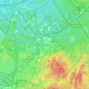
Name: Vierhouten topographic map, elevation, terrain.
Location: Vierhouten, Nunspeet, Geldern, Niederlande (52.29948 5.77246 52.36521 5.88095)
Average elevation: 32 m
Minimum elevation: 9 m
Maximum elevation: 75 m
Other topographic maps
Click on a map to view its topography, its elevation and its terrain.
Elspeet
Niederlande > Geldern > Nunspeet
Elspeet, Nunspeet, Geldern, Niederlande
Average elevation: 29 m