Geolocate

Zlatograd topographic map

Click on the map to display elevation.

About this map

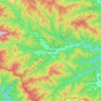
Name: Zlatograd topographic map, elevation, terrain.

Location: Zlatograd, Smolyan, 4980, Bulgaria (41.34091 25.05500 41.42091 25.13500)

Average elevation: 563 m

Minimum elevation: 341 m

Maximum elevation: 856 m

Other topographic maps

Click on a map to view its topography, its elevation and its terrain.

Chepelare

Bulgaria > Smolyan

Average elevation: 1,354 m

Gear up for your next adventure:

🎒Fully Waterproof Backpack - Total protection for photography gear and electronics
🧦Hiking Socks - Moisture-wicking and comfortable socks for long hikes
🚲MTB Frame Bag - Carry tools and maps directly on your bicycle frame
🥾Waterproof Hiking Boots - Essential footwear for rugged terrain and wet Canadian trails
🔋Lithium AA Batteries - Long-lasting power that performs in extreme cold

As an Amazon Associate, this site earns from qualifying purchases at no extra cost to you.