Geolocate

Damascus topographic map

Click on the map to display elevation.

About this map

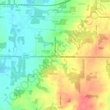
Name: Damascus topographic map, elevation, terrain.

Location: Damascus, Mahoning County, Ohio, 44619, United States (40.88200 -80.97509 40.92200 -80.93509)

Average elevation: 368 m

Minimum elevation: 334 m

Maximum elevation: 412 m

Other topographic maps

Click on a map to view its topography, its elevation and its terrain.

Sebring

United States > Ohio > Mahoning County

Average elevation: 340 m

Craig Beach

United States > Ohio > Mahoning County

Average elevation: 293 m

Boardman

United States > Ohio > Mahoning County > Boardman

Average elevation: 323 m

New Middletown

United States > Ohio > Mahoning County

Average elevation: 371 m

Poland

United States > Ohio > Mahoning County

Average elevation: 323 m

Struthers

United States > Ohio > Mahoning County

Average elevation: 302 m

Austintown

United States > Ohio > Mahoning County > Austintown

Average elevation: 327 m

Gear up for your next adventure:

Camping Essentials - All-in-one gear for a comfortable camping trip
🧥Waterproof Pants - Keep dry during rainy hiking conditions
🏃Hydration Running Vest - Carry water and maps close to your body for speed
Bushcraft Tarp - Versatile emergency shelter or gear protection
🦟Insect Repellent - Keep mosquitoes and black flies away in wooded areas

As an Amazon Associate, this site earns from qualifying purchases at no extra cost to you.