
Make a donation
Gear up for your next adventure:
As an Amazon Associate, this site earns from qualifying purchases at no extra cost to you.
Lillaz topographic map
Click on the map to display elevation.
Make a donation
Gear up for your next adventure:
As an Amazon Associate, this site earns from qualifying purchases at no extra cost to you.
About this map
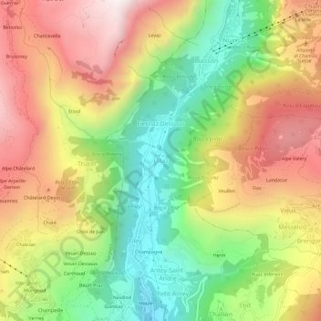
Name: Lillaz topographic map, elevation, terrain.
Location: Lillaz, Antey-Saint-André, Aosta Valley, 11020, Italy (45.79889 7.57175 45.83889 7.61175)
Average elevation: 1,545 m
Minimum elevation: 971 m
Maximum elevation: 2,163 m
Make a donation
Gear up for your next adventure:
As an Amazon Associate, this site earns from qualifying purchases at no extra cost to you.
Other topographic maps
Click on a map to view its topography, its elevation and its terrain.
Make a donation
Gear up for your next adventure:
As an Amazon Associate, this site earns from qualifying purchases at no extra cost to you.
Make a donation
Gear up for your next adventure:
As an Amazon Associate, this site earns from qualifying purchases at no extra cost to you.
Make a donation
Gear up for your next adventure:
As an Amazon Associate, this site earns from qualifying purchases at no extra cost to you.
Saint-Vincent
Saint-Vincent (Valdôtain: Sèn-Veuncein; Issime Walser: Finze) is a town and comune in the Aosta Valley region of north-western Italy. Saint-Vincent, elevation 575 metres (1,886 ft), is a popular summer holiday resort with mineral springs.
Average elevation: 1,179 m