Geolocate

Monte Rosa Massif topographic map

Click on the map to display elevation.

About this map

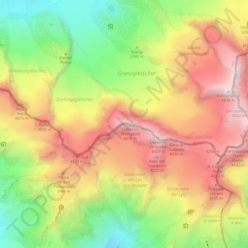
Name: Monte Rosa Massif topographic map, elevation, terrain.

Location: Monte Rosa Massif, Gressoney-La-Trinité, Aosta Valley, Italy (45.91665 7.76650 45.93695 7.87627)

Average elevation: 3,478 m

Minimum elevation: 2,425 m

Maximum elevation: 4,619 m

Other topographic maps

Click on a map to view its topography, its elevation and its terrain.

Gear up for your next adventure:

🚲Handlebar Phone Mount - View topographic-map.com live while cycling
🥾Light Trekking Boots - Supportive boots for multi-day treks
Camping Groundsheet - Protect your tent from moisture and dirt
🥾Waterproof Hiking Boots - Essential footwear for rugged terrain and wet Canadian trails
🏕️Camping Hammock - Integrated protection for sleeping between trees

As an Amazon Associate, this site earns from qualifying purchases at no extra cost to you.