Geolocate

Addison topographic map

Click on the map to display elevation.

About this map

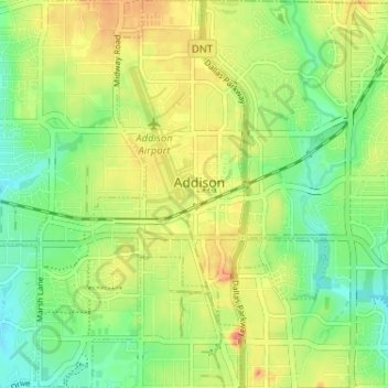
Name: Addison topographic map, elevation, terrain.

Location: Addison, Dallas County, Texas, United States (32.93315 -96.85595 32.98721 -96.80777)

Average elevation: 187 m

Minimum elevation: 163 m

Maximum elevation: 214 m

Other topographic maps

Click on a map to view its topography, its elevation and its terrain.

Dallas

United States > Texas > Dallas County > Dallas

Dallas and its surrounding area are mostly flat. The city lies at elevations ranging from 450 to 550 feet (137 to 168 m) above sea level. The western edge of the Austin Chalk Formation, a limestone escarpment (also known as the "White Rock Escarpment"), rises 230 feet (70 m) and runs roughly north–south…

Average elevation: 158 m

Garland

United States > Texas > Dallas County > Garland

Average elevation: 164 m

Irving

United States > Texas > Dallas County > Irving

Average elevation: 162 m

Mesquite

United States > Texas > Dallas County > Mesquite

Average elevation: 145 m

Gear up for your next adventure:

🧊Insulated Water Bottle - Keeps drinks cold in summer and prevents freezing in winter
🪑Insulated Seat Pad - Protect your seat from cold rocks and wet logs
🥾Trekking Boots - Durable boots for long-distance trekking
🧴First Aid Kit - Essential first aid supplies for outdoor emergencies
🦶Hiking Shoe Insoles - Added support for high arches and long days on feet

As an Amazon Associate, this site earns from qualifying purchases at no extra cost to you.