Geolocate

Garland topographic map

Click on the map to display elevation.

About this map

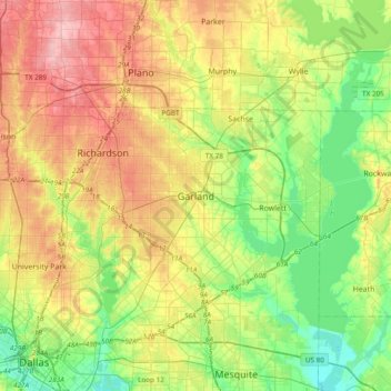
Name: Garland topographic map, elevation, terrain.

Location: Garland, Dallas County, Texas, 75040, United States (32.75262 -96.79888 33.07262 -96.47888)

Average elevation: 164 m

Minimum elevation: 113 m

Maximum elevation: 235 m

Gear up for your next adventure:

🥾Trekking Poles - Adjustable trekking poles to reduce knee stress and improve stability
💧Hydration Bladder - Hands-free hydration solution for long treks
🧭GPS Tracker - Track your location in remote areas safely
🥾Mountain Hiking Shoes - Shoes with superior grip for mountainous terrain
🧳Compression Sacks - Maximize space in your backpack by shrinking gear

As an Amazon Associate, this site earns from qualifying purchases at no extra cost to you.