
Lake Titicaca topographic map
Interactive map
Click on the map to display elevation.
About this map
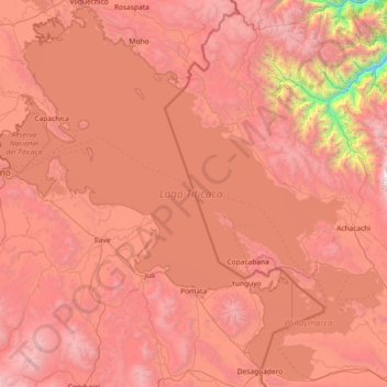
Name: Lake Titicaca topographic map, elevation, terrain.
Location: Lake Titicaca, Puno, Peru (-16.59816 -70.03591 -15.23333 -68.56834)
Average elevation: 3,870 m
Minimum elevation: 1,428 m
Maximum elevation: 5,797 m
Lake Titicaca has a surface elevation of 3,812 m (12,507 ft). The "highest navigable lake" claim is generally considered to refer to commercial craft. Numerous smaller bodies of water around the world are at higher elevations. For many years, the largest vessel afloat on the lake was the 2,200-ton (2,425 U.S. tons), 79-metre (259 ft) SS Ollanta. Today, the largest vessel is most likely the similarly sized train barge/float Manco Capac, operated by PeruRail.
Other topographic maps
Click on a map to view its topography, its elevation and its terrain.
Lecce Pata
Lecce Pata, Corani, Province of Carabaya, Puno, Peru
Average elevation: 4,436 m
San Fracisco
San Fracisco, Putina, Province of San Antonio de Putina, Puno, Peru
Average elevation: 3,902 m
Province of San Antonio de Putina
Province of San Antonio de Putina, Puno, Peru
Average elevation: 4,299 m
Province of San Antonio de Putina
Province of San Antonio de Putina, Puno, Peru
Average elevation: 3,612 m