
Sinai Peninsula topographic map
Interactive map
Click on the map to display elevation.
About this map
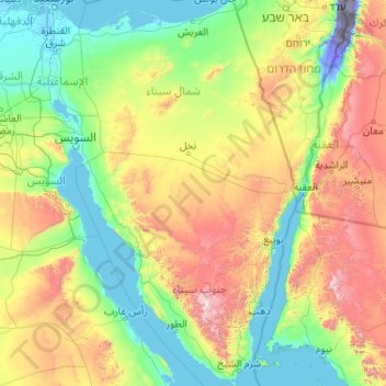
Name: Sinai Peninsula topographic map, elevation, terrain.
Location: Sinai Peninsula, Egypt (27.72414 32.31018 31.32347 34.90369)
Average elevation: 457 m
Minimum elevation: -415 m
Maximum elevation: 2,521 m
Other topographic maps
Click on a map to view its topography, its elevation and its terrain.
Borj Al Burullous
Borj Al Burullous, Kafr El Sheikh, Egypt
Average elevation: 0 m
Mudiriyat al Gharbiyah
Mudiriyat al Gharbiyah, Seberbay, مديرية الغربية, Western, 31733, Egypt
Average elevation: 46 m
Tizmant East Village
Tizmant East Village, Bani Sweif, 62725, Egypt
Average elevation: 30 m
Shubra al Khayma
Shubra al Khayma, Al Qalyubiya, 13771, Egypt
Average elevation: 45 m
El Farafra Oasis
Egypt > New Valley Governorate > El Farafra Oasis
El Farafra Oasis, New Valley Governorate, Egypt
Average elevation: 103 m
Ras El Bar
Egypt > Damietta > Al Bar Cape
Ras El Bar, Kornish Al Nile Street, Al Bar Cape, Damietta, 34712, Egypt
Average elevation: 1 m
Kharga Oasis
Egypt > New Valley Governorate > Kharga Oasis
Kharga Oasis, New Valley Governorate, Egypt
Average elevation: 95 m
Faiyum Oasis
Egypt > Faiyum Governorate > Ezbet Mahmud Pasha Fahmi
Faiyum Oasis, Faiyum Governorate, Egypt
Average elevation: 32 m
Abu Minqar
Egypt > New Valley Governorate > Abu Minqar
Abu Minqar, New Valley Governorate, Egypt
Average elevation: 143 m
Mount Catherine
Egypt > South Sinai > St Catherine
Mount Catherine, St Catherine, South Sinai, Egypt
Average elevation: 2,315 m
Al Rasdisia Qebly City
Egypt > Assouan > Al Rasdisia Qebly City
Al Rasdisia Qebly City, Assouan, 81718, Egypt
Average elevation: 96 m
Sabkha of El Qattara Depression
Egypt > Giza Governorate > Abu Al Gharadiq
Sabkha of El Qattara Depression, Petrol Abu Sannan Road, Abu Al Gharadiq, Giza Governorate, Egypt
Average elevation: 43 m
El Gouna
Egypt > Red Sea Governorate > El Gouna
El Gouna, Red Sea Governorate, 84513, Egypt
Average elevation: 8 m
Suez Canal
Egypt > Ismailia Governorate > Al Ismailiya
Suez Canal, Al Ismailiya, Ismailia Governorate, Egypt
Average elevation: 6 m
New Damietta
Egypt > Damietta Governorate > New Damietta
New Damietta, Markaz Shirbin, Damietta Governorate, Egypt
Average elevation: 1 m