Geolocate

Lladurs topographic map

Click on the map to display elevation.

👉 Easily get elevation data in JSON, GeoTIFF and KML formats using Elevation API
Thank you for supporting this site ❤️
Make a donation

About this map

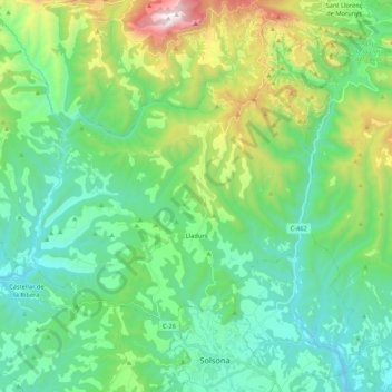
Name: Lladurs topographic map, elevation, terrain.

Location: Lladurs, Solsonès, Lleida, Catalonia, 25288, Spain (42.00942 1.36774 42.11179 1.58042)

Average elevation: 869 m

Minimum elevation: 521 m

Maximum elevation: 1,920 m

Other topographic maps

Click on a map to view its topography, its elevation and its terrain.

Su

Spain > Catalonia > Solsonès

Su, belongs to the municipality of Riner, in the comarca of Solsonès, vegueria of Comarques Centrals (Catalonia). Su is situated at an elevation of 726 meters above sea level.

Average elevation: 738 m

Su

Spain > Catalonia > Solsonès

Su, belongs to the municipality of Riner, in the comarca of Solsonès, vegueria of Comarques Centrals (Catalonia). Su is situated at an elevation of 726 meters above sea level.

Average elevation: 738 m

Canalda

Spain > Catalonia > Solsonès > Odèn

Average elevation: 1,288 m

la Coma

Spain > Catalonia > Solsonès > la Coma i la Pedra

Average elevation: 1,308 m

Gear up for your next adventure:

👖Convertible Hiking Pants - Zip-off legs to adapt to changing weather conditions
🧦Hiking Socks - Moisture-wicking and comfortable socks for long hikes
🥾Trail Running Shoes - Lightweight and durable shoes for trail running
🥾Hiking Leggings - Comfortable leggings for outdoor activities
🥾All-Terrain Hiking Boots - Versatile boots for varied hiking conditions

As an Amazon Associate, this site earns from qualifying purchases at no extra cost to you.