
Area C (Old Fort/Charlie Lake) topographic map
Interactive map
Click on the map to display elevation.
About this map
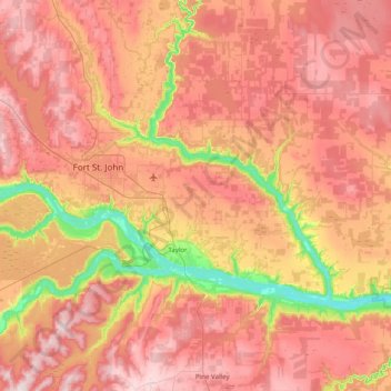
Name: Area C (Old Fort/Charlie Lake) topographic map, elevation, terrain.
Average elevation: 669 m
Minimum elevation: 388 m
Maximum elevation: 894 m
Other topographic maps
Click on a map to view its topography, its elevation and its terrain.
Fort St. John
Canada > British Columbia > Peace River Regional District
Fort St. John, Peace River Regional District, British Columbia, Canada
Average elevation: 676 m
Crescent Park
Canada > British Columbia > Peace River Regional District > Dawson Creek
Crescent Park, Dawson Creek, Peace River Regional District, British Columbia, Canada
Average elevation: 687 m
Jack Lake
Canada > British Columbia > Peace River Regional District > Area B (Finlay Valley/Beatton Valley)
Jack Lake, Area B (Finlay Valley/Beatton Valley), Peace River Regional District, British Columbia, Canada
Average elevation: 996 m
Buckinghorse River
Canada > British Columbia > Peace River Regional District > Area B (Finlay Valley/Beatton Valley)
Buckinghorse River, Area B (Finlay Valley/Beatton Valley), Peace River Regional District, British Columbia, Canada
Average elevation: 945 m
Pine River
Canada > British Columbia > Peace River Regional District > Area E (Moberly Lake/Sukunka Valley)
Pine River, Area E (Moberly Lake/Sukunka Valley), Peace River Regional District, British Columbia, Canada
Average elevation: 973 m
Parkland
Canada > British Columbia > Peace River Regional District > Area D (Kiskatinaw Valley)
Parkland, Area D (Kiskatinaw Valley), Peace River Regional District, British Columbia, Canada
Average elevation: 726 m
Williston Lake
Canada > British Columbia > Peace River Regional District
Williston Lake, Peace River Regional District, British Columbia, Canada
Average elevation: 1,191 m
Tumbler Ridge
Canada > British Columbia > Peace River Regional District
Tumbler Ridge, Peace River Regional District, British Columbia, V0C 2W0, Canada
Average elevation: 1,153 m
Windfall Lake
Canada > British Columbia > Peace River Regional District > Area E (Moberly Lake/Sukunka Valley)
Windfall Lake, Area E (Moberly Lake/Sukunka Valley), Peace River Regional District, British Columbia, Canada
Average elevation: 1,655 m
Moberly Lake
Canada > British Columbia > Peace River Regional District > Area E (Moberly Lake/Sukunka Valley)
Moberly Lake, Area E (Moberly Lake/Sukunka Valley), Peace River Regional District, British Columbia, Canada
Average elevation: 886 m
Dawson Creek
Canada > British Columbia > Peace River Regional District
Dawson Creek, Peace River Regional District, British Columbia, Canada
Average elevation: 700 m
Mount Russel
Canada > British Columbia > Peace River Regional District > Area B (Finlay Valley/Beatton Valley)
Mount Russel, Area B (Finlay Valley/Beatton Valley), Peace River Regional District, British Columbia, Canada
Average elevation: 1,651 m
Montney
Canada > British Columbia > Peace River Regional District > Area B (Finlay Valley/Beatton Valley)
Montney, Area B (Finlay Valley/Beatton Valley), Peace River Regional District, British Columbia, V0C 1Y0, Canada
Average elevation: 718 m
Chetwynd
Canada > British Columbia > Peace River Regional District
Chetwynd, Peace River Regional District, British Columbia, V0C 1J0, Canada
Average elevation: 910 m
Clayhurst
Canada > British Columbia > Peace River Regional District > Area B (Finlay Valley/Beatton Valley)
Clayhurst, Area B (Finlay Valley/Beatton Valley), Peace River Regional District, British Columbia, Canada
Average elevation: 644 m
Hudson's Hope
Canada > British Columbia > Peace River Regional District > Hudson's Hope
Hudson's Hope, Peace River Regional District, British Columbia, V0C 1V0, Canada
Average elevation: 748 m
Buckinghorse River
Canada > British Columbia > Peace River Regional District > Area B (Finlay Valley/Beatton Valley)
Buckinghorse River, Area B (Finlay Valley/Beatton Valley), Peace River Regional District, British Columbia, Canada
Average elevation: 1,200 m
Valley View
Canada > British Columbia > Peace River Regional District > Area D (Kiskatinaw Valley)
Valley View, Area D (Kiskatinaw Valley), Peace River Regional District, British Columbia, Canada
Average elevation: 657 m
Area D (Kiskatinaw Valley)
Canada > British Columbia > Peace River Regional District
Area D (Kiskatinaw Valley), Peace River Regional District, British Columbia, Canada
Average elevation: 1,024 m
East Pine
Canada > British Columbia > Peace River Regional District > Area E (Moberly Lake/Sukunka Valley)
East Pine, Area E (Moberly Lake/Sukunka Valley), Peace River Regional District, British Columbia, Canada
Average elevation: 664 m
Fort St. John
Canada > British Columbia > Peace River Regional District > Fort St. John
Fort St. John, Peace River Regional District, British Columbia, V1J 3Z3, Canada
Average elevation: 650 m
Area B (Finlay Valley/Beatton Valley)
Canada > British Columbia > Peace River Regional District
Area B (Finlay Valley/Beatton Valley), Peace River Regional District, British Columbia, Canada
Average elevation: 1,098 m
Obo Lake
Canada > British Columbia > Peace River Regional District > Area B (Finlay Valley/Beatton Valley)
Obo Lake, Area B (Finlay Valley/Beatton Valley), Peace River Regional District, British Columbia, Canada
Average elevation: 1,300 m
Taylor
Canada > British Columbia > Peace River Regional District
Taylor, Peace River Regional District, British Columbia, V0C 2K0, Canada
Average elevation: 498 m
Area E (Moberly Lake/Sukunka Valley)
Canada > British Columbia > Peace River Regional District
Area E (Moberly Lake/Sukunka Valley), Peace River Regional District, British Columbia, V0C 1T0, Canada
Average elevation: 1,025 m
Pink Mountain
Canada > British Columbia > Peace River Regional District > Area B (Finlay Valley/Beatton Valley)
Pink Mountain, Area B (Finlay Valley/Beatton Valley), Peace River Regional District, British Columbia, Canada
Average elevation: 1,531 m
Sikanni Chief
Canada > British Columbia > Peace River Regional District > Area B (Finlay Valley/Beatton Valley)
Sikanni Chief, Area B (Finlay Valley/Beatton Valley), Peace River Regional District, British Columbia, Canada
Average elevation: 875 m