
Montney topographic map
Click on the map to display elevation.
Montney
It lies at an elevation of 700 meters (2,300 ft), along the BC Rail tracks.
About this map
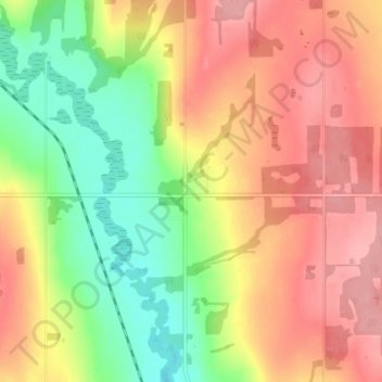
Name: Montney topographic map, elevation, terrain.
Average elevation: 718 m
Minimum elevation: 659 m
Maximum elevation: 769 m
Peace River Regional District trails, hiking, mountain biking, running and outdoor activities
Other topographic maps
Click on a map to view its topography, its elevation and its terrain.
Obo Lake
Canada > British Columbia > Peace River Regional District > Area B (Finlay Valley/Beatton Valley)
Average elevation: 1,300 m
Jack Lake
Canada > British Columbia > Peace River Regional District > Area B (Finlay Valley/Beatton Valley)
Average elevation: 996 m
Inga Lake
Canada > British Columbia > Peace River Regional District > Area B (Finlay Valley/Beatton Valley)
Average elevation: 865 m
Buckinghorse River
Canada > British Columbia > Peace River Regional District > Area B (Finlay Valley/Beatton Valley)
Average elevation: 945 m
Milligan Hills Provincial Park
Canada > British Columbia > Peace River Regional District > Area B (Finlay Valley/Beatton Valley)
Average elevation: 875 m
Charlie Lake
Canada > British Columbia > Peace River Regional District > Area B (Finlay Valley/Beatton Valley)
Average elevation: 761 m
Buckinghorse River
Canada > British Columbia > Peace River Regional District > Area B (Finlay Valley/Beatton Valley)
Average elevation: 1,200 m