Geolocate

Berne topographic map

Click on the map to display elevation.

About this map

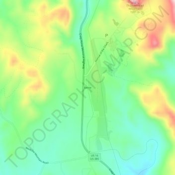
Name: Berne topographic map, elevation, terrain.

Location: Berne, Custer County, South Dakota, United States (43.79748 -103.65881 43.83748 -103.61881)

Average elevation: 1,799 m

Minimum elevation: 1,693 m

Maximum elevation: 1,984 m

Other topographic maps

Click on a map to view its topography, its elevation and its terrain.

Pringle

United States > South Dakota > Custer County

Average elevation: 1,518 m

Hermosa

United States > South Dakota > Custer County

Average elevation: 1,017 m

Lakota Lake

United States > South Dakota > Custer County

Average elevation: 1,409 m

Gear up for your next adventure:

Lightweight Camping Tent - Portable shelter optimized for Canadian backcountry camping
Camping Tent - Weather-resistant tents suitable for 2 to 6 people
Lightweight Backpacking Tent - Compact tent for efficient hiking trips
🧰Survival Kit - Essential gear for emergencies in the wilderness
👟Sport Hiking Sandals - Breathable footwear for water crossings and camp rest

As an Amazon Associate, this site earns from qualifying purchases at no extra cost to you.